


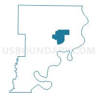
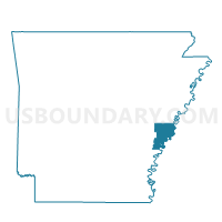
Bush Voting District, Phillips County, Arkansas
About
Outline

Summary
| Unique Area Identifier | 527600 |
| Name | Bush Voting District |
| County | Phillips County |
| State | Arkansas |
| Area (square miles) | 24.98 |
| Land Area (square miles) | 24.98 |
| Water Area (square miles) | 0.00 |
| % of Land Area | 100.00 |
| % of Water Area | 0.00 |
| Latitude of the Internal Point | 34.46048900 |
| Longtitude of the Internal Point | -90.74263520 |
Maps

Graphs
Select a template below for downloading or customizing gragh for Bush Voting District, Phillips County, Arkansas


Neighbors
Neighoring Voting District (by Name) Neighboring Voting District on the Map
- Hornor 1 Voting District, Phillips County, AR
- Lake Voting District, Phillips County, AR
- Lakeview Voting District, Phillips County, AR
- Searcy 3 Voting Distrct, Phillips County, AR
- Spring Creek 1 Voting District, Phillips County, AR
- St. Francis 2 Voting District, Phillips County, AR
Top 10 Neighboring County Subdivision (by Population) Neighboring County Subdivision on the Map
- Hornor township, Phillips County, AR (9,697)
- St. Francis township, Phillips County, AR (4,746)
- Spring Creek township, Phillips County, AR (1,789)
- Tappan township, Phillips County, AR (1,500)
- Lake township, Phillips County, AR (41)